We made it to Smithers!
Category:Recreational ResearchHey Big Guy! We made it to Smithers! Cheery welcome from on old furry friend in the airport foyer. And from Reg Collingwood #Spatsizi
Demographic Analysis To Manage And Market Your School
Hey Big Guy! We made it to Smithers! Cheery welcome from on old furry friend in the airport foyer. And from Reg Collingwood #Spatsizi

A menu, a wine list, a backdrop of beautiful Vancouver harbour…aaahh … we’re finally off on Air Canada to #Spatsizi

The big winners and losers in the 2022 Election can be seen in our online interactive ADS 2022 Election Map. The five big players in 2022 were the traditional majors: the ALP and the Coalition, but also the minor parties, like the Greens, the Teals and the Others (including One Nation and the UAP). The
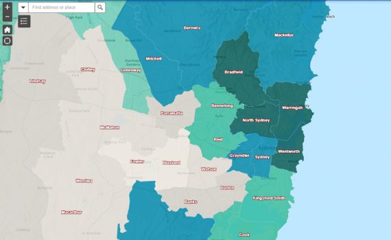
If you want to know which federal seats are most likely to swing strongly to the Teal candidates at the Federal election on May 21, check out the 🔗Map below. The map shows the percentage of top income quartile persons in 2022 Federal seats in darker shades of teal and is modelled by ADS from

Monday 20th June, 2022 Party Machines Conking Out by John Black – AFR – Editorial and Opinion To Read click link 🔗 Financial Review, Monday, June 20, 2022, pages from 36 to 37 -1.pdf 2022 Federal Election Swing Map The big winners and losers in the 2022 Election can be seen in our online interactive

If you want to know which federal seats were more likely to show swings to the Opposition at the start of this election campaign, then the Esri map in this link isn’t a bad place to start. Link 🔗 2022 FEDERAL ELECTION KEY INDICATORS (arcgis.com) EThe online Esri map uses the latest Australian Electoral Commission

Profiling of the Voices 2019 demographics by Australian Development Strategies shows that grassroots campaigns by Voices candidates against Liberals in 2022 – led by professional women – could be even more devastating for Labor MPs if turned against them in 2025. This means that the Federal election of 2022 is not so much a contest

Our EGS Spatial Analyst and Senior Mapper Dr Jeanine McMullan has just recorded a new video. In the video, headed The Power of the Esri Map Module, Jeanine conveys her sense of excitement at being able to explore innovative new map layers of small-scale data which she can superimpose on EGS catchment maps, so schools

Using available data from late 2021, the Education Geographics team calculated post-Covid spatial estimates from 2020 to 2031 on total population, pre-schoolers and school-aged children. Our preliminary EGS population modelling indicates that the big winners from Covid impacts on total Australian population growth have been the four SA4 ABS statistical regions making up the state

In late 2021, Australia appears headed for a strong economic recovery, but underlying structural problems mean this is no time for complacency among school leaders about future demand for Non-Government school places in 2022 and beyond. As outlined in the Australian Financial Review today (December 2, 2021) Economics Editor John Kehoe warns the current publicly-funded


